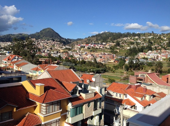
Ecuador, Azogues
FC-01x Future Cities (Self-Paced) - Exercise 1 : "Making the Invisible - Visible"

Uploaded on 2016-09-22 by María José Mogrovejo
1. Visible Information This picture is from Azogues, a very small city located in south Ecuador. With almost 40000 habitants, Azogues is located in a small hill in which top is constructed a very beautiful church called ‘’San Francisco’’, a place where many people of all over Ecuador goes to pray. The picture shows a residential city, where most of its buildings are constructed by two or three floors. The boundary between urban and rural spaces is not well defined. Most of new buildings are constructed in rural areas, such us this neighborhood where i live in. Rural areas are starting to be fill of new buildings, making Azogues Bigger, but in Azogues, you can not see a well-controlled URBAN growth that goes around the most peripheral areas adjacent to the city, but a uncontrolled RURAL growth that does not mind the proximity to the city. In fact, if you look at the panoramic picture, it is very visible that probably the urban population of Azogues (40000 habitants) is not much more than the rural population shown in the picture (around 20000 habitants). Finally, people living largely in rural areas have the same economic stratum that those living in urban areas. In many cases, the economic status of people in rural areas is higher than those living in urban areas. Then, why people do not live in urban areas but in rural? Uncontrolled rural growth will be always a expensive way of growth of cities. 2. Invisible Information • We could analyze urban and rural zoning (urban and rural land uses), and correlate this information with the preferences of citizens living in both areas. So we could know the percentage of citizens who depend on one or other land use. For example, understanding the proportion of green areas for recreational use in urban and rural areas; people living in rural areas may prefer to live near green areas (absent in urban areas) to help decrease stress of their jobs. • If the price of sqm of land in Azogues is almost the same in urban and rural areas (250/m2inurbanareasVS 150 / m2 in rural areas), we could analyze the preferences of the population in reference to lot size depending on their activities. For example: The population living in rural areas may prefer to spend a little time to agricultural activities. If so, the city planning should control the size of lots to allow families do their relaxing activities. 3. How this invisible information can become knowledge and contribute to city planning. • If we analyze zoning Vs preferences of citizens (The first invisible information i posted), we could replan urban areas, considering land uses required by the population. If the city offers to its people what they require, we would have a well-controlled growth and a less-expensive economic invertion.