United States, New York City
FC-01x Future Cities (Self-Paced) - Exercise 1 : "Making the Invisible - Visible"
Uploaded on 2017-05-24 by Francesca
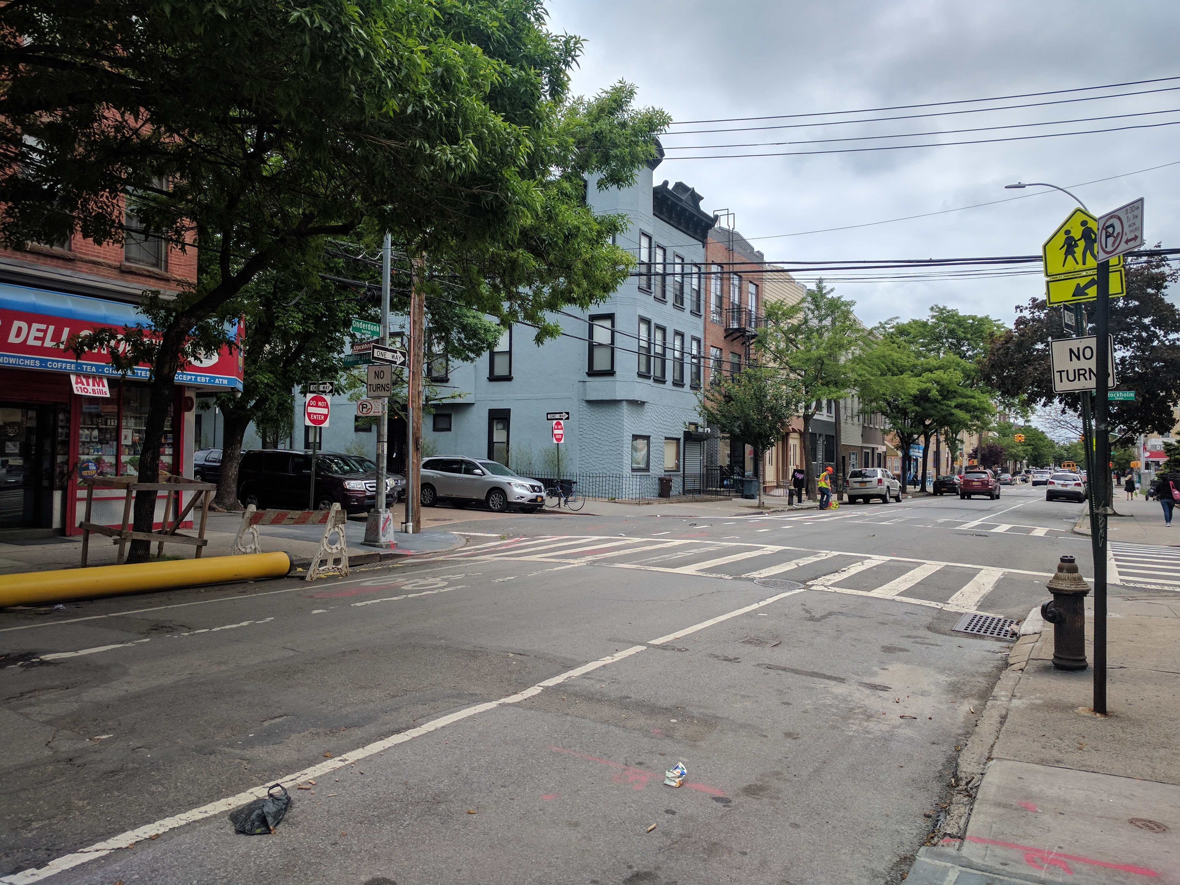
1. Upload a photo from your area, or the closest urban area, (the photo must be taken by you) and comment all the information that is visible in this photo. Photo: New York City, USA (more specifically, Ridgewood, Queens) Name: Francesca Gallo The visible information in this photo, taken in New York City, USA (more specifically Ridgewood, Queens) includes… • The buildings are smaller and mostly residential, potentially reflecting that the purpose of this neighborhood is largely residential • The materials used to build the buildings range from brick to wood siding, with varying architecture reflecting that they may have been built asynchronously • There is a pedestrian crossing sign, suggesting that there is a good deal of pedestrian foot traffic in the area • Most of the visible streets are one-way, and there is only one stoplight across two blocks, suggesting that this area is not built for heavy car traffic • There are few businesses visible; those that are visible are smaller, independent and occupy the first floors of residential buildings (a bodega/deli in the foreground, a pharmacy down the block), but there are no corporate businesses • The presence of nature/greenery is limited to the trees lining the block • The sidewalks and roads are cracked, the paint worn down, clearly suffering from wear and tear, and suggesting that maintenance to this area has been minimal • The sidewalks and roads also have visibly different materials that they are comprised of, suggesting that the maintenance that has been done in this area has been ad hoc • There is a construction worker measuring out something at the end of the road, and construction materials in the foreground, suggesting that this area is in the process of infrastructure-level repair • There is a bike lane and a bike locked up to a pole suggesting that this is a viable form of transportation in this area • There is an alternate street side parking sign (regulations about when to park/where) • There are telephone and internet wires stretched across the street rather than down the street, suggesting that this neighborhood was originally built without this type of infrastructure considered • There are relatively few pedestrians on the street or cars on the road at the time that this photo is taken (midday, weekday) • The school bus in the far background of the photo suggests that this is an area where kids either live or go to school 2. Identify and present two "invisible information" that can be extracted out of the visible information of this photo. • Invisible Information #1: This area (New York City, USA; more specifically, Ridgewood, Queens) has seen a rapid and perhaps unexpected increase in foot, bike and car traffic in recent years. This invisible info can be extracted by the visible stress to sidewalks and roads: potholes, cracks, crumbled curbs, worn paint. These sidewalks and roads were not originally built for this level of traffic. It can also be extracted from the visible effort seen here to update the neighborhood to accommodate the increase in traffic when and where possible (ad hoc renovation) without disrupting the flow of traffic entirely. For example different materials used to patch and update the road and sidewalk in small parts, not as a whole, as well as the addition of a bike lane. • Invisible Information #2: The purpose of this area (New York City, USA; more specifically, Ridgewood, Queens) and the activities of citizens in the area have not seen much change in recent years, even while the area has seen an increase in population density. This continues to be a residential neighborhood area where, on the whole, people live, not where they got to work. This can be extracted from the fact that the construction taking place is infrastructure renovation: gas line updates to accommodate more people living in the area. The newer buildings visible are modernized versions of the older buildings they flank; they do not shift the purpose or composition of the street. The few existing businesses serve the direct and day-to-day needs of residents more than they would serve passers-by. There are no restaurants or entertainment venues to attract people who live elsewhere to visit. In addition, the absence of people in the neighborhood at midday on a weekday (when this photo was taken) suggests that they are away at their places of work. 3. Select one of your choices from the previous question and describe how this invisible information can become knowledge and contribute to the planning of a more livable urban space. • Invisible Information #2: Given that this area (New York City, USA; more specifically, Ridgewood, Queens) is seeing an increase in density but not a shift in purpose (it’s still a place residence rather than a place of business), the citizens who occupy this area will soon be in need of more residential-centric resources per capita and perhaps more diverse residential resources if the population composition shifts with its increased density (often the case in New York City). To create a more livable urban space, planning should accommodate for resources that serve families as well as those that would serve young adults without children, and that can manage heavy traffic flow at peak work-travel hours (going to work and coming home from work). One example to this end might be a big and diversely purposed green space, constructed to provide hubs of privacy and hubs where people can socialize and meet others in their neighborhood. Another example would be city-sponsored bike racks to encourage and facilitate more bike traffic and less car traffic in the area and therefore cut down on rush hour jams.