France, Montpellier
FC-01x Future Cities (Self-Paced) - Exercise 1 : "Making the Invisible - Visible"
Uploaded on 2017-02-06 by Clement OLIVA
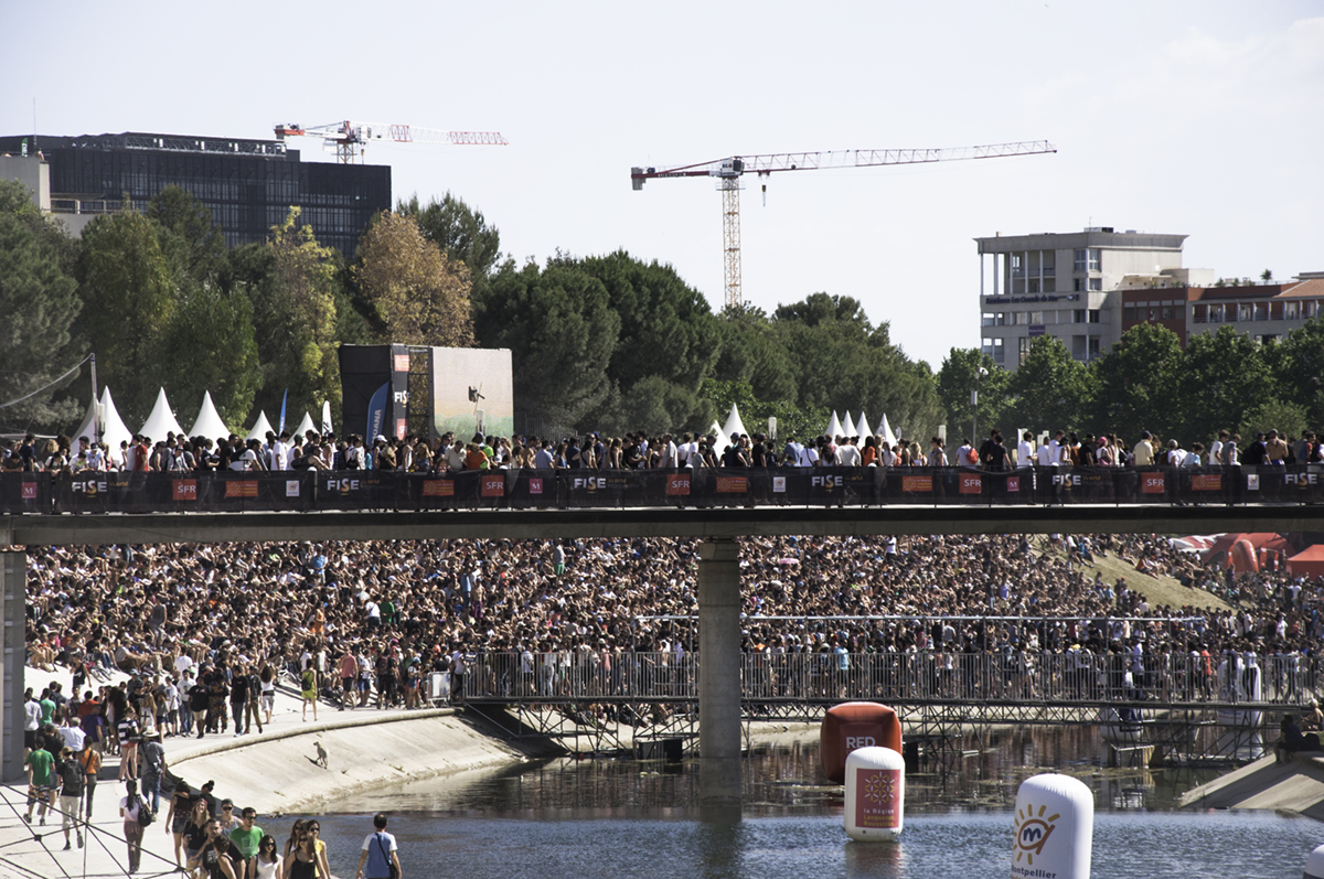
3.6.1 Commenting This picture was taken in june 2014, during an annual bike show in Montpellier, France. This event lasts a few days, and is publicly and privately sponsored. Taking this picture, I am standing on a bridge above the main river of the city, in the direction of the mediterranean sea. The next bridge pictured, full of people, is restricted to pedestrians by design. To the right, out of the picture you will find the historic center of the city where all the tramway network and train station connect. You need ten to fifteen minutes of walking to get there. During the event, there is a true displacement of centrality in the city. To the left, at no distance but out of vision you have some student housings and business oriented universities. The dark building behing an alley of trees is the bright new city hall. The cranes are helping the achievement of high budget hotels and high quality housing rising next to the city hall. The entire area has been build since the eighties. And for the obvious part, the amount of people you can see here is stunning. Even the annual fireworks does not attract so many inhabitants. It is very important to know that there is not enough car parks at short distance for everyone here. 3.6.2 Invisible information What we cannot know from this picture is where are these people from ? At what part can we find inhabitants of Montpellier (and from what district), and other people from others cities around ? Also, what transportation infrastructure did they use on their journeys ? Tramway, trains, bus, by car, or just walking ? 3.6.3 Improvements The river banks are very crowded on this photograph. As the sport event goes on , this is part of the fun : you are enjoying the sun, being with friends, being part of something. The issues come later with the evening, when the crowd splits : the festive part , the families, etc. By collecting enough data about the places of origins, the city administration may use it to prevent congestion, and adapt the frequency and efficiency of each type of transport method (number of tramway in activity, price of parking, closing or opening streets…). I’ll add that with a better understanding of the crowd behaviour, the city could implement day-to-day regulations to the area : temporary shops, food trucks authorisations, temporary circulation map, temporary tram stations etc, that can lead to an increase in the attractiveness of the event and then the city.