Australia, City of Parramatta
FC-01x Future Cities (Self-Paced) - Exercise 1 : "Making the Invisible - Visible"

Uploaded on 2017-01-25 by Michael Maxwell
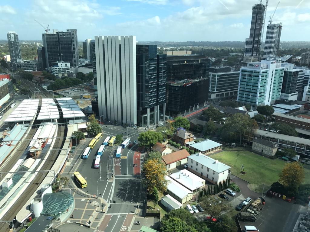
Making the invisible - visible 1. Upload a photo from your area, or the closest urban area, (the photo must be taken by you) and comment all the information that is visible in this photo. This photo was taken by me, Michael Maxwell, of part of the central business district of Parramatta in NSW, Australia. Parramatta is generally regarded as Sydney’s second CBD and is currently undergoing extensive development. A number of visible pieces of information are worth noting: - The black building in the centre of the photo is a newly established CBD campus for Western Sydney University. It is one of several campuses that the university has scattered across Western Sydney and the only one situated in a CBD location. - The development of residential towers on both sides of the photo are indicated by the presence of cranes. These towers, the taller of which, when complete, will be the tallest residential tower in Sydney, sit atop multi-storey retail/commercial podiums. Residential towers extend out of picture to the right of the photo. - The major transport hub, visible on the centre left of the picture, is Parramatta railway station. The station is located on the main western rail line and most trains stop here. In the centre front of the photo is one of two main bus interchanges. Another is just visible on the left of photo on the other side of the railway station. This latter interchange is adjacent to a large shopping mall (the edge of which is just visible in the picture), the second largest in Sydney. - The green space at the front right of the photo belongs to a line of schools and a military barracks. A very large public park is located on the far side of the CBD and is visible as an area of trees just to the left of the tallest tower under construction. - Just visible behind the building in the centre of the photo is a sizable construction site. This development, in the very heart of the CBD, will comprise a number of commercial/ residential towers, each rising from an integrated, permeated retail/commercial podium. 2. Identify and present two "invisible information" that can be extracted out of the visible information of this photo. Invisible information , such as that which can be extracted from this photo, will describe factors that are, at the same time, both descriptive and prescriptive. The Singapore transport system discussed in the course content is an excellent example of the dual nature of invisible information. In that example the live usage data was both ‘descriptive’ – providing data on people movements, points of origin and destination, peak usage times, and user groups – and ‘prescriptive’ – the transport corridors would influence where business locates, where people travel, the location of housing supply, and, to a certain degree, property values. The invisible data associated with this photo of Parramatta will have this dual nature. Enrolment data relating to the Western Sydney University’s CBD campus will provide information on: - the demographic mix of the student cohort - students’ residential status and location - course preferences - the specific course offerings by the university - academic performance - attendance patterns. Invisible information obtainable from development applications in relation to the construction of the high rise towers will provide data on the anticipated property market. The configuration of the development will influence the nature and character of the city: - 3 – 4 bedroom apartments would be targeted to either attract families to inner city living or provide shared student accommodation - 2 -3 bedroom apartments would be targeted to professional couples working in the city - studio or one bedroom apartments would be targeted at singe professionals or accommodation for affluent students - Boarding house (or other affordable) accommodation would be targeted at students, lower paid workers or the socially disadvantaged. 3. Select one of your choices from the previous question and describe how this invisible information can become knowledge and contribute to the planning of a more livable urban space. The configuration of residential development can contribute considerably to planning a livable urban space. The development occurring in the photo will have a prescriptive influence on the future population of the city and will influence not simply the demographic mix of the CBD population, but also: - the nature of business (including restaurants) that establish in the area - the nature of entertainment, including street entertainment, and recreation facilities - the configuration of roadways and pedestrian malls - the location of transport nodes and associated routes and timetables. In short, the development will have flow on effects on where and how people shop, eat, recreate and travel. Awareness of this data will be critical to effective social planning.