Module 8: Task 2: Urban Systems – The impact of infrastructure on urban form: The case of Antipolo City, Province of Rizal, Philippines
FC-01x Future Cities (1st Run) - Task 2

Uploaded on 2016-05-06 by Jasonbsantos
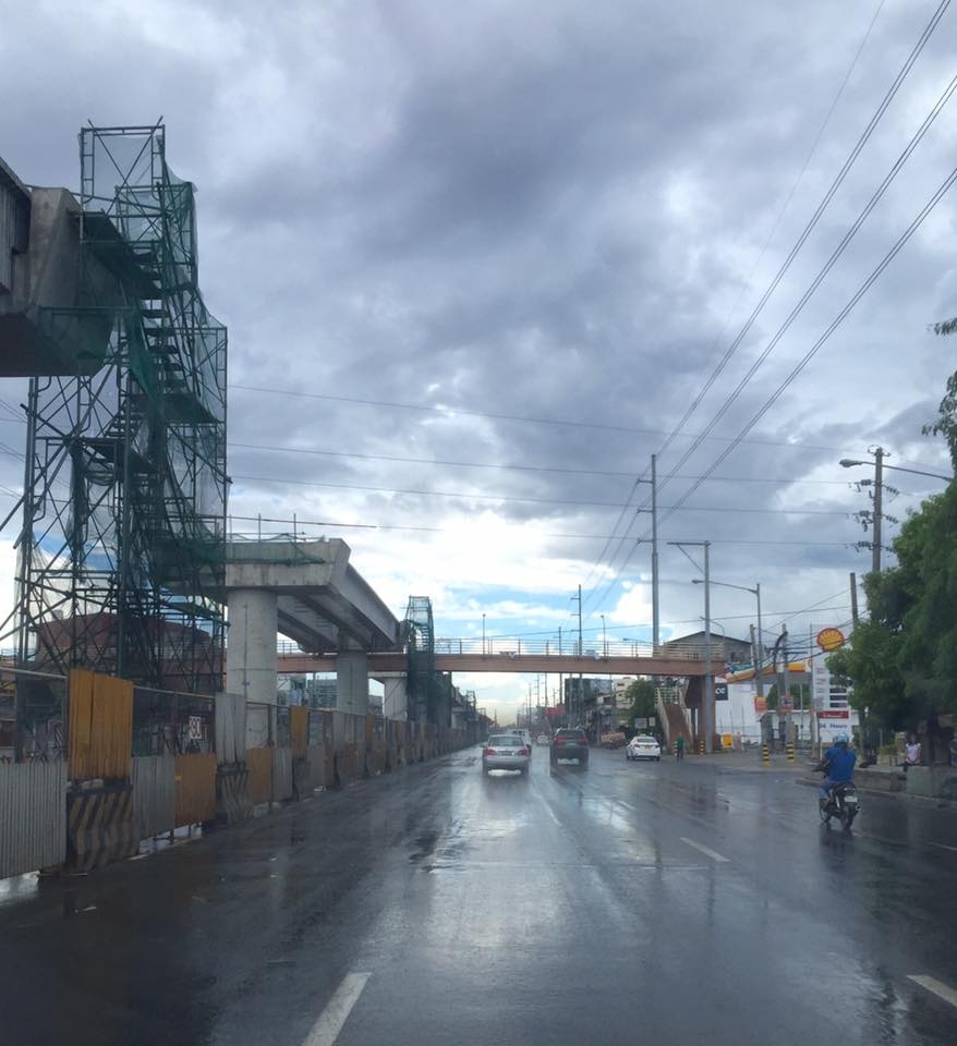
[1]: https://edxuploads.s3.amazonaws.com/14625251307066934.jpg The photograph shows a major highway (Marcos, Marilaque Highway or R-6) that navigates multiple cities in the Philippines namely Antipolo, Marikina and Quezon City. At the center of the highway is a new national government project. A new elevated railway is being constructed connecting the cities along this highway and ends in the City of Antipolo which is labelled as the “Pilgrimage Capital of the Philippines”, due to its numerous pilgrimage sites and churches. Also, Antipolo City is considered a highly urbanized city to date. Considering the urban form of the city, the highway is considered as the main spine going in and out of the city leading to the Central Business District zones and to the provincial areas in the other side. Looking at this information, the railway project is placed in this part of the city that is serving its visitors, being a destination site; serving its inhabitants, wherein the city has predominantly residential areas and also accommodating passersby going to the hinterlands and other provinces in the eastern part of Manila. It is safe to assume that the planners and implementers of this massive project used an urban system design that engaged the threefold pillars of modelling, simulation and projection in the solution that was realized. It is imperative to note that the urban energy infrastructure system in the Philippines is primarily anchored on transmission lines that traverse the city highways and streets that distributes to the buildings and establishments. As seen in the picture, the highway is lined with electrical transmission lines that as the module transcript explained; over-head transmission lines is an efficient infrastructure of electricity distribution however, it ruins the landscape view or architectural character and also has potential health and safety risks. There are electrical lines that are parallel along the highway and there are also lines that transect the highway that poses a threat to health and safety. In the middle part of the photograph is a steel pedestrian overpass or walkway that is in the direct alignment of the elevated railway slab. It is fair to assume that the structure was provided in a “temporary” basis for pedestrian movement, as this would be a waste of government resources which can either be reused or integrated in the upcoming transportation infrastructure. The infrastructure project supports the Philippine governments’ thrust for “inclusive growth and development” wherein equal opportunities and access for all citizens. As explained in the transcripts, urban system succeed if there is a collaboration with all stakeholders and encouraging a “bottom-up” approach in design and planning. This makes the city sustainable and resilient in the future, as mass transportation accompanied by the power infrastructure is a key component as evidenced by the new train system infrastructure of Antipolo City. Framing the transportation and energy infrastructure, it definitely influences to a certain extent the urban form of the city. There are also outside forces that bring impact to the form such as politics, topography and climate. With regard to the Antipolo City’s link to the rural areas, as stated that, urban systems are connected to its hinterland or rural systems. The connection must be seamless, unobstructed and gives importance to decent “vistas” or views. Observing the case of Antipolo city, its fringes are majority rural given the city center is highly urbanized – as evidenced by the railway project and the span of the main highway. Both the urban and rural communities of Antipolo complement each other, thus, the pilgrimage destination label. It is also interesting to recognize the interconnection of Antipolo to other adjacent cities and municipalities like Marikina, Pasig, Cainta, Taytay, San Mateo, Rodriguez, Angono, Teresa and Quezon City. Therefore, the urban area of Antipolo City is associated to its rural area and is linked for development; literally by the main transportation infrastructure.