Uploaded on 2015-12-15 by ishanpal13
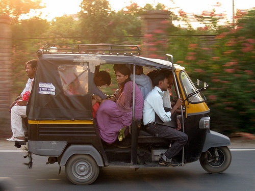
Citizen design project: Around my city we have these vehicles called Shared Autos or tuk tuks (as you can see in the picture). It is basically a bigger version of an auto rickshaw. It can comfortably hold 6 people on it and it's a very cheap way to travel around the city as they have set routes and if you want to go anywhere on that route all you have to do is pay 10 rupees. Hence it is preferred by a lot of people due to its pricing. And they cover most of this town. The problem is that while the autos cover most of the town no one is sure which one will take you were exactly unless you have only one destination everyday which does not require you to switch autos. So if i want to go to a certain area, firstly i will just go stand randomly at the main road hoping that one of them will come my way. Secondly there is no stop exactly so i have to really work hard to try and stop one. Some of them would by-pass me because they're overloaded. My proposal is to map their movement, and find out all the different routes taken by all the different autos. then we would know all the available routes ad know which streets are missing any autos and create new routes accordingly. Also taking to account if people have to switch autos which routes need to join and where. After which we first put the maps out and make official stops for these autos. These could be placed at a distance of a 5 min walk. And every junction where a lot of routes are meeting could be made into a smaller transport hub. To make it more convenient to understand we will have to number the routes and colour code them and paint the front of the autos with that colour accordingly. This way if any of the autos are not in their own route they could be fined. This helps organising this system so that every layman could understand it easily and maybe use it more often than taking their private cars out every time. With an organised system they the auto drivers can also be accountable to breaking the rules of the system. The great part of this is that, this system which they have between them has developed organically. And so the structure being applied later will not ruin the system. Plus if they have their dedicated stops then they wont tend to stop wherever and whenever. With this system known by the citizens they would too make sure the auto drivers are not breaking any rules. There already exists and organised system for shuttle busses with specified routes in this city but they have very few routes. if we could combine the system into one map it would make it easier for people who might want to do longer distances in these autos. ![I do not own the right to this photograph. I got it from http://farm3.static.flickr.com/2233/3526884095_2e1907591e.jpg][1] [1]: http://farm3.static.flickr.com/2233/3526884095_2e1907591e.jpg