Malta, Valletta
FC-01x Future Cities (Self-Paced) - Exercise 1 : "Making the Invisible - Visible"
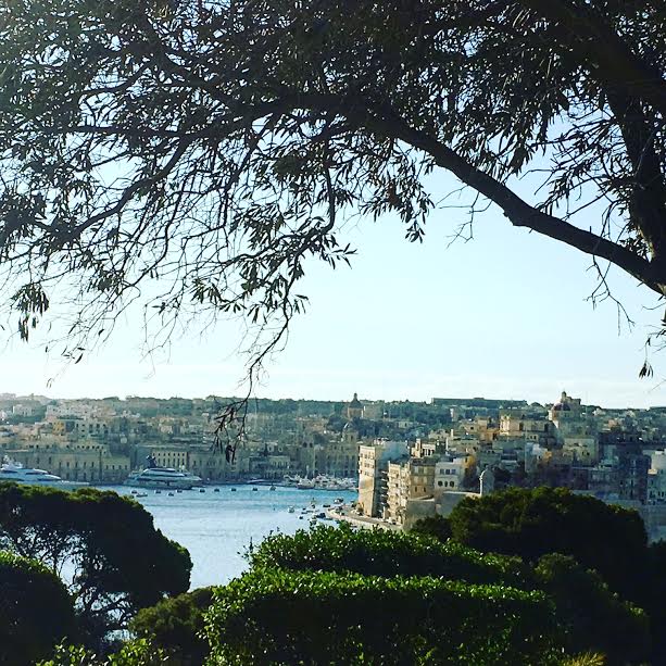
Uploaded on 2017-05-21 by Rachel Cluett
We are looking at a view of the capital city of Malta, Valletta - most definitely an urban area. This is made obvious from the following VISIBLE information that the image portrays: 1. Numerous buildings 2. Roads with moderate traffic 3. Boats stationed in the port 4. Large yachts indicating a certain status among users of that travel method One can conclude that the buildings and travel vehicles constitute most of the VISIBLE information. Please note that different times of the day can make a difference when noting VISIBLE information. For example, if the picture was taken at night we might be able to note which areas are more active due to lighting. INVISIBLE: 1. What are the buildings used for? Residential/Commercial? Business/Leisure? 2. Patterns of traveling to the city. For example, the relation between [how much the city is traveled to] with the [time of year/day] 3. How different areas of the city attract different people - most simplified as "Who goes where?" Taking point no.2, i.e. Patterns of traveling to the city. For example, the relation between [how much the city is traveled to] with the [time of year/day] please see the following notes on HOW the data that is extracted can be useful. 1. Discovering relations/connections within the demographics via travel methods. Let's say that during the winter time and in the mornings (when the city isn't as 'commuted to' with all types of people as is in the summer months) we find that more adults (18+) are traveling to the city for work, whereas more children (under 18 years of age) are exiting the city for the day to go to schools located elsewhere. This can help with organising transportation & road safety methods. Take another situation - in the evenings & throughout the weekend, it is found that more adults(18+) are commuting to and roaming the streets of the city due to the Capital City's nightlife. In this way we are making the relation between the time of day/week, age groups, travel methods and functions in certain areas of the city. The patterns noted can help in all aspects.