Uploaded on 2015-06-16 by InmaSanMillan
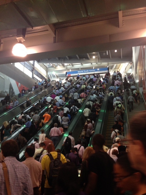
This is the Path Train arriving to World Trade Center. The data that we can extract from here are transportation patterns. New York contains a good bunch of different layouts of travel behaviors. On the one hand, you can find people coming into the City, every morning, weekdays. They make the same itinerary in the same direction in the mornings. From Penn Station, Port Authority Bus Terminal and Paths to Financial District, thousands of people come into the City every day same hour, and they walk, as if they were an orchestrated performance, towards the East of the City, with an average high speed and looking to the ground, with a coffee in a disposable glass and all of them looking the same, with their two-pieces suits and their snickers. All this people disappear in the buildings, and when the work day is over, they are vomited from the office buildings and they go back along all the way back towards their homes, far away. Long commuting. We get also to meet other kind of characters, those walking the dogs, skating in Bryant Park or sitting around. Or tourist who don´t believe the migration flow they are witnessing. With this “invisible information” you can get the transportation patterns of the city. You can get other “invisible” information, the quality of the different spaces. There are the paths, formed by sidewalks (for pedestrians), streets (for buses and taxis) and the noise. And some now and then, there are empty, calm spaces that remain as witnesses of the chaos and act as livable small spots in the middle of the flurry. I like to understand a city so alive as this one as a space where activity must coexist with life. And the qualification of the spaces, the empty ones or the overbooked ones, which needs each other tough, defining strongly their differences. We won´t be able to design more livable cities if we don´t accept their movements and necessities. Two opposed concepts but that cannot survive without each other. We have to learn, studying these “invisible information”, how people travel, their different interests (tourism, work, leisure…), how different age groups are, and how they prefer to travel depending on the different times of the day or the different kinds of activities. It also can help us identify the critical situations, as the volumes in junctions in peak hours and traffic flows, or the trouble that the mixing of different activities can bring to the engine of the city. Understanding the different urban dynamics in the town – the joggers, the newspapers sellers, the tourists, the commuters, the dog walkers…- have to be considered in order to help urban functionality. ![Commuters to Wall Street. New York][1] [1]: https://edxuploads.s3.amazonaws.com/14344207983697018.jpg