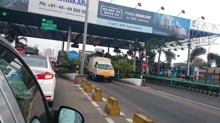
Highway Toll- Chennai-India
FC-01x Future Cities (1st Run) - Exercise 1 : "Making the Invisible - Visible"

Uploaded on 2015-05-13 by Naffasandy
this picture is taken by me in Chennai India, on OMR road. this road connects the suburban part with the city hub. we can see the highway tolls and special lanes for private cars, public transportation and trucks that carry goods. As a visible information also we can see that private cars lane is more crowded at the time the picture was taken in.Also smart cards are used to pay. we see palm trees on the right side and we see towers after crossing the toll which indicates the starting of the urban part Two invisible information we can extract from the visible information: 1. studying the data collected from the toll smart card system, we can have information about the peak hours where traffic will be extreme towards the city or the suburban area. 2. by studying the data also collected by the toll, we can have information about the users of this highway if private cars or public buses or trucks that carry goods. 3. The invisible information that can become knowledge and be used to plan the city: if we study the data collected by the toll about the people who cross this highway, private of public and on the time they do, we can have an idea about their daily travel purpose, if they live in city and work in suburban or the opposite. also if young people (students) cross it to which side. we can have an idea about the urban functions and about the purpose of travelling and we can plan functions that are important to the urban pattern we get. as for examples if many numbers of students cross this highway towards the city in morning time and towards the suburban in evening time, we might consider building schools and universities in suburban areas, this will be lead to less daily transportation and less energy consumption and less traffic. [1]: https://edxuploads.s3.amazonaws.com/14314967305215728.jpg [2]: http://