Uploaded on 2015-04-22 by DanielaB333
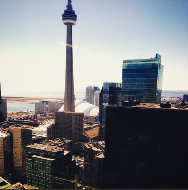
[1]: https://edxuploads.s3.amazonaws.com/14297420068255932.jpg This image was taken from the 35th floor of the Toronto-Dominion Centre in downtown Toronto. 1. Visible Information: The skyscrapers in the area, the CN Tower, the white dome which is the Rogers Center, the waterfront with some smaller residential condos along the shore, the sunlight and angles at this time of day and the shadows that it casts, the reflections in the glass curtain walls, part of the Toronto Islands in the distance on the left side, a small grassy area of a park at street level in the centre of the photo, the Gardiner Expressway (highway) and Lakeshore Boulevard with cars travelling on there, the various usage of construction materials for different buildings such as concrete, glass, etc. the various heights of structures, the lack of boats on the water (our waterfront is unfortunately very underdeveloped), as well as the Greater Toronto Area far away on the right hand side of the photo. 2. Two pieces of invisible information that can be extracted: I would say that you can guess the density in the area/downtown core. Due to the tall skyscrapers that are in the photo, Toronto is trying to fit as many people as possible into a small amount of space. Densification is created and building vertically is essential in this area. You can assume that this location is the core of the city due to important landmarks/attractions such as the tower and the skydome. Another piece of invisible information that can be extracted from this photo is the traffic congestion in the city. Due to the large amount of skyscrapers visible there are clearly many people being fit into a small area on a daily basis. When these people commute to and from, they each use their own car (for the most part) and North American cars tend to be quite large. This creates a disastrous amount of traffic on the small streets and is extremely bad for the environment as well. Not only is there a large amount of cars, but also a large amount of pedestrians. Therefore, crosswalks and stoplights at intersections are very frequent throughout the city to allow pedestrians to get by. This creates even more traffic since cars are continuously stopping and going due to frequent stoplight intersections. 3. How invisible information can contribute to planning a more liveable space: People can use this invisible information about congestion and the density in the area to create a better transportation system. If more people used public transportation in the city, less cars would be used and the traffic would greatly decrease. However, Toronto has a very poor and limited transit system. The subway does not have very many lines or stops to all areas of the city, and a large percentage of Toronto's public transportation is either buses or streetcars which run at streetlevel and add to the traffic congestion. By looking at people's commuting patterns and routes most frequently taken, decisions can be made towards improving the public transportation. Streetcars are a nuisance since they stop at every corner and run on the same street lanes as cars. This means that cars must stop at every corner behind streetcars to allow passengers to board, and bypassing a streetcar is quite difficult. Taking out the streetcar and instead improving the underground transportation would be a smart idea and support a more liveable urban space in the future.