Active (in) Singapore
FC-01x Future Cities (1st Run) - Exercise 1 : "Making the Invisible - Visible"

Uploaded on 2015-04-21 by Martevanderhoeven
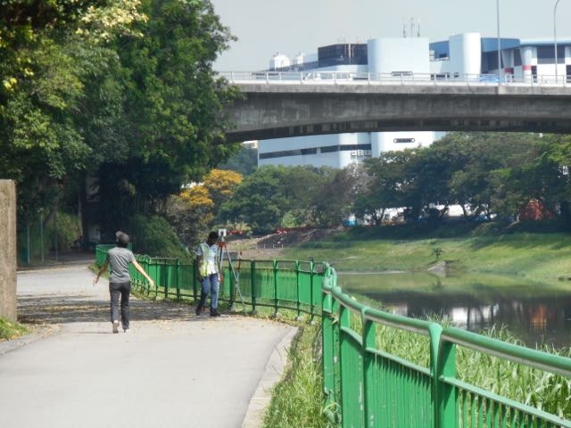
Visible information: we see two persons on a concrete pathway, one female walking and looking up to the left, and one male worker with a building measurement instrument. On the left of the road/pathway there are quite lush green trees and a concrete block about 2,5m high. Along the right side of the pathway there is a green fence next to a green grass strip along a seemingly meandering river or canal. On the other side of the waterway there is a green strip, one line of trees and no fence visible. In the background across the waterway there is a big white building looking like a manufacturing plant or huge warehouse. In front of this crossing the river is a concrete bridge with dimensions to carry vehicular traffic. The weather is sunny, the surrounding seems tropical and well maintained (grass on other side of waterway mowed, no potholes in concrete, no graffiti, no litter - only some leaves on the concrete paving, building in background white white). Invisible information: it is indeed tropical climate as this is the city of Singapore and its morning, about 10am on a weekday and approx. 30 degrees C. Singapore is a highly organised, clean, regulated city, of which you see elements in this photo. The concrete pathway is indeed a walking/cycling path not for use by motorised transportation - the so-called Connector Path, connecting diverse cycling/walking paths across the city. The lady is presumaly leisurely or active walking, which is a common outside exercise you see across the city. The worker is undertaking height measurements for yet another construction, possibly involving the concrete block (foundation of some sort) on the left side. The bridge is indeed a 4-6 lane typical road in Singapore with at this time of the morning not too much traffic. The green fence is positioned there to discourage people to get near to the water - a safety measure as well as to prevent litter/contamination of the waterbody and to prevent massive water/picknick activities outside dedicated areas which are situated in the parks along the connector path. The PUB - waterbody in SP - has been/is very active in the clean up and now maintaining healthy water quality at this used to be very dirty water stream. Thee city's aim is not only to ensure good quality waterresources and a healthy living environment, but also a safe and (over)dimensioned storm water drainage system across the city - to account for pressing climate change issues the city is facing. Clear edges along the riverbank that can act as buffer storage is a pure necessity at times of ongoing heavy rainfall events. Knowledge: By regularly monitoring waterlevels and water quality as well as ecological (wild)life, fish and plants present in the area etc., the city has good knowledge of the waterbody system in terms of capacity and flow dynamics, the resilience of the corridor once events occur (spillage, heavy storm, dry period), the fish stock and variety of animals and plants and general ecological system and its behaviour. This knowledge is useful for future and current planning at diverse governmental bodies, and the data itself can be used as input in diverse modelling exercises, again to support decision making or understanding system behaviours in advance of event happening. Total other data: the usage of the connector path would be nice to monitor and i can imagine lead to knowledge about social patterns or social dynamics indicating what the effect of such pathway on the community is (when connected to other data as adjacent residents or existing parks etc.). etc. etc. [1]: https://edxuploads.s3.amazonaws.com/14295841167544902.jpg