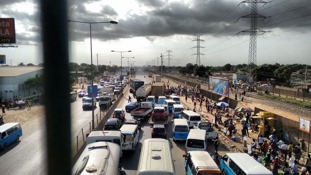
A Car Crash that tells a lot: People attidude, transportation flow, and layout.
FC-01x Future Cities (1st Run) - Exercise 1 : "Making the Invisible - Visible"

Uploaded on 2015-04-29 by SamuelHWUK
Picture taken in the Estrada de Catete highway, Viana, city of Luanda - Angola I have to cheat because this picture doesn't tell the whole story, so I will have to give you a bit of background: A pedestrian crossed the road with no due care, leading to a car crash between 2 semi-trucks and a 6 hours traffic Jam. The angle of the picture is high, because I was walking on a nearby pedestrian bridge that crosses the same road, you can see the security grading in the picture. So for me this picture have some hidden information shown: 1- People attitude matters: Even though a safe and convenient crossing point, a bridge, is provided pedestrians insist in crossing the road on the dangerous way. This creates of course a dangerous situation, illustrated by the crash, but also it slows down the car traffic as you can see because on the side of the road with no crash you can still see a small traffic. So even if infrastructure is provided, peoples attitudes can be an issue. But this is not only the pedestrian fault, the public taxis also create traffic jam by stopping at this same spot to try to "fish" passengers from people that crossing the bridge, this is both due to lack of proper taxi stop and also due to taxi lack of culture of orderly parking. So the infrastructure created to ease traffic, creates it by both people who don't want to used it and people who do use it, albeit indirectly. 2- Managing flow, not just allowing high flow: Basically what you have at this spot also is a supermarket right near the highway, so there is a lot of traffic in and out of the spot, which disturbs the high flow of traffic. So the lesson here is that high density roads is one part of the story, we also have to create appropriate entry and exit points, so as to not disturb the flow. 3- Layout: The placement of a high density usage area, such has supermarket in this case, near the high flow artery is part of this picture as it creates a hot spot where pedestrian flow, car traffic flow, logistic flow crosses. Maybe it would be better if these three flows were to be decoupled. 4- Crampedness: The picture also tells the information of crampdness, as not only is pedestrian and car flows occupying the same space, but also train track and electricity conduits also follow the same axis, this leads to each components limiting space available for the construction and expansion of each. A last aspect of crampedness the picture doesn't show clearly is that even commerical spaces and residential spaces are cramped in the same space, as the high flow arteries, both of pedestrians and cars, is valuable as it has a concentration of customers and has the value of ease of transportation. This picture shows that a set of paralel flow paths for people and cars might be required. [1]: http://i601.photobucket.com/albums/tt91/pamba/IMG_20150415_1553489861.jpg [2]: http://