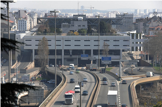
Perrache, Lyon, France.
FC-01x Future Cities (1st Run) - Exercise 1 : "Making the Invisible - Visible"

Uploaded on 2015-06-17 by vlabrevo
[1]: https://edxuploads.s3.amazonaws.com/1434299993274640.png This is a photography of Perrache, one of the main transportation hubs in Lyon, France. Built in the 70s Perrache is altogether a train, subway, tramway, bus station and is traversed by the A7 motorway which is one of France’s most heavily travelled highways. What we can first see is the causeway leading the A7 from over the Saone (one of lyon's rivers) to under the transportation hub. What we can see in the Perrache transportation hub are parked buses waiting for passengers. On the roof of the hub we can appreciate the gardens of Perrache and their vegetation. On the left and right sides of the hub we can see alleyways leading buses to and from their halt at Perrache. Finally we can apprehend the fact that the Perrache transportation hub and the A7 over which it is built is surrounded on its left and right by residential buildings in the very heart of Lyon. There is much invisible information to be inferred from the visible in this picture. However I wish to bring out the two most important issues that can be extracted from this of Perrache: Pollution and spatial segregation. We can deduct from the freeway present in the picture that the area is polluted with high noise levels and also high levels of particle matter pollutions lowering air quality. Therefore quality of life in the immediate surroundings of the A7 is depreciated. The photography also puts forward the physical division that the A7 and the hub create in the middle of Lyon. What can be deduced from such a spatial division is a form of spatial segregation between the southern part on the right of the picture and the northern part on the left, with little intermixing from residents from the north and south with each other. As a matter of fact the two neighborhoods are socially very different, the southern part being an ex-industrial zone in reconversion is the home to many immigrant and working class families (and is rather infamous as a neighborhood where traffic occurs) while the north is home to more ‘upper class’ families. The first step in solving a problem is realizing there is one, the second being finding its causes. Here, by looking at the photography we have realized that a spatial division in the city can be the source of spatial segregation and a deterrent to intermixing populations. The problem here is the clear divide between two neighborhoods that can be a source of tensions and lack of opportunity for the less privileged neighborhood. One of the causes of this divide is the physical division we have seen in the picture. In this precise case, to plan for a more liveable environment one should seek to reduce the importance of the physical division, to alter the social homogeneity of the two neighborhoods and create more opportunity for intermixing between the populations of the two sides. As of today many steps have been made to go towards such changes. Firstly a tramway line been created to reduce the importance of the physical division. Secondly a housing project know as ‘la confluence’ has built quality apartments intended for both social housing and for ‘upper class’ families as a way of reducing social homogeneity. Finally, many office spaces have been built, as well as a mall to provide work and make the neighborhood attractive.