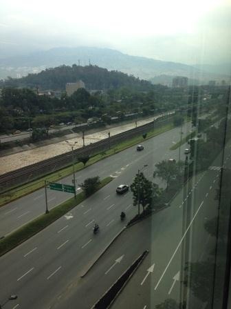
Medellín, Colombia Highway and Metro
FC-01x Future Cities (1st Run) - Exercise 1 : "Making the Invisible - Visible"

Uploaded on 2015-04-17 by jgaceved
[1]: https://edxuploads.s3.amazonaws.com/14293016949032775.jpg Visible Information: the most important highway of the city call "la Regional" cross the entire city alongside the Medellin River from north to south, where is also located the principal line of the Metro that in the whole city doesn’t have tracks underground. Invisible Information: Despite the color of the river the local government has been working on several projects to clean the water and integrate the river to the life of citizens since 2010. The traffic seems really calm but that’s because of the hour I took the picture (3:00pm), but at rush hours either the Metro or the highway can’t deal properly with the amount of people that is trying to get home from their work places. Understanding and regulating through local policies different working hours for people in offices, will considerably improve the movement of passengers in public and private transportation in the city. The local governments has built and keep building good infrastructure projects that are really ahead of the country average like the Metro Cable, a cable car to reach the steeps parts of the city mountains and the Tranvia. All of these project have really contribute to the quality of life of people, but understanding how and when people move is the key to organized the system a little bit better to reduce the time it takes to get to and from work.