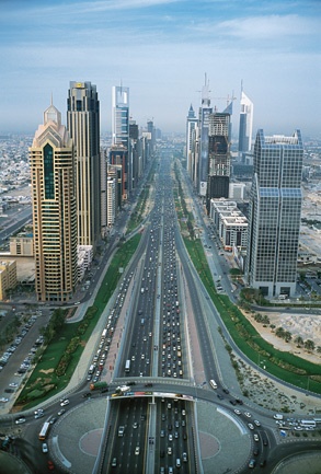
Sheikh Zayed Road- Dubai
FC-01x Future Cities (1st Run) - Exercise 1 : "Making the Invisible - Visible"

Uploaded on 2015-06-17 by NedaSa
**Visible information:** The first thing that catches our eye is the highway with its dominant lanes and the way they serve the high-rise buildings lining up at the edge of the road while there is a little less going on at the back of these rows of the buildings and some areas are still not developed. The main highway is separated from the local roads by some greenery areas, which is mostly grass, and some shrubs. The traffic is heavier on the right side and we can observe some heavy vehicles within them and there is no specific distinction between the bus/bicycle/truck lanes. **Invisible information:** what is not conceivable from the picture is the atmosphere of this area and the way it changes within the 24 hours, the green areas might seems like a "break space" but the temperature gets so high during the day due to natural climate and the heat island effect that this space is not usable and due to extreme amount of noise coming from the cars basically any ground level activity in the open space is doomed, there is heavy traffic in the rush hour and its hard to find a parking space. ![enter image description here][1] Reference: http://www.sandierpastures.com/wp-content/uploads/2010/12/szroad.jpg [1]: http://s3.amazonaws.com/mitx_askbot_stage//1434520756758923.jpg