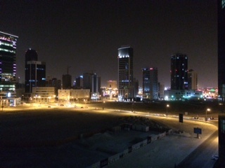
Making the invisible -visible - Seef in Bahrain
FC-01x Future Cities (1st Run) - Exercise 1 : "Making the Invisible - Visible"

Uploaded on 2015-05-01 by Rowbo
[1]: https://edxuploads.s3.amazonaws.com/14304854433199183.jpg 1. Visible information: the built environment in terms of number of towers, height of towers (number of floors), proximity, level of lighting at night; land use - between built and bare land; and roading. 2. Invisible information that could be extracted: use of current building stock (ie residential, commercial, retail, leisure, parking (basement and other parking options) - and energy usage for living or working including lighting and cooling; waste management); occupancy of current building stock and roading during 24 hours and across days of the week. 3. Occupancy information could help to inform the efficiency of the use of the current built environment and how it could be improved in regard to efficient use of energy, lift management and cooling and for example if there is a large number of residential or weekend workforce in the buildings but no nearby food outlets then this could inform decisions on future tenants and new development to increase the livability of this area. Occupancy information could also help to inform the design and planning of the bare land seen in the front of the image. If parking is an issue in the existing built environment with only 70% occupancy for example then planners could determine that any new developments must include additional parking facilities (public transport is very limited in Bahrain and we also experience very hot summers so most people drive to and from their destinations as walking outside is a challenge in 40+ degrees C).