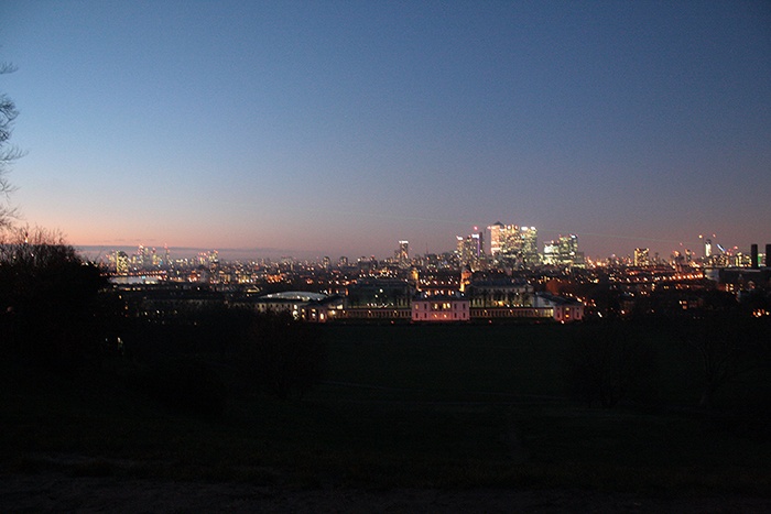
Making the invisible / visible – City of London
FC-01x Future Cities (1st Run) - Exercise 1 : "Making the Invisible - Visible"

Uploaded on 2015-05-28 by Chiara7
I choose a picture like that to try to say something about the information that night photos can give to us. I’d like to divide in two the invisible information which the photo has. 1. **Characters of the territory** (natural and artificial environment). It is possible recognize some natural and artificial elements. We can see the River Thames along its way from the center of the City to the peripheral boroughs of Canary Wharf and Greenwich. The Green areas - in the foreground, Greenwich Park and around the other city parks - are without light during the night and we can see clearly their borders. Furthermore the picture’s point of view allows us to know information about the levels of the lands. The second type of information is about the artificial elements that the city has. We can see the huge business boroughs of the ‘City’ (on the left) and ‘Canary Wharf’ (on the right), with tower buildings and high level density environments; we see also some historical and public buildings like the Natural Maritime Museum in the foreground. This elements and their relationship are part of the basic knowledge for future actions. 2. **Links and city system** The picture shows also the system of transport and links. The lighting is an important element to determine the outline of the main connection between natural and artificial elements. The light can be fixed or moving: for example the fixed light helps us to understand the position of the roads and the public transport (trains and underground but also airport, port, etc.); moreover the movement of the lights (like cars and buses) shows the importance of some links and give us the hierarchy of the elements. The movement of the lights is an important clue to understand the movement of the people (habitant and inhabitant of the city) and give us information about some areas with more attraction points than others. The lighting also allows to understand the function of the buildings. During the night/evening, the residential areas and the social/services buildings (hospitals, clubs, restaurants, cinemas, etc.) are busy. We see the light in these buildings and we can make an assumption about the use of them. How can this information be useful for the knowledge of the city and contribute to planning a more livable urban space? I’m interested in the first point, the character of the territory. The knowledge which derives from the picture explains the important rules that have influenced the current status of the city. Huge green spaces surround London, other ones are located in the middle of its center. The green areas have to be preserved but sometimes it is not enough to create a border of protection and make new rules. The best way to preserve the green belts is to preserve the links with the city boroughs, with the residential clusters, with the habitant and inhabitant people of the city. The only way to achieve that, is to share the quality of the ‘invisible’ services that nature give to the city. The participation of the people in the preservation of the green spaces is an essential key of the contemporary city. For example if the green areas are reachable conveniently by the people, it is a service for them and make them conscious about the importance of the preservation. Improving the transport system is also a way to link as much as we can the natural elements with the lives of the people. **Green belts** and **cultural elements** have to be linked with the business areas with fast transport and with the residential boroughs also. Another example is the **river Thames**, one of the most important natural elements; the Thames is a border, because it interrupt the city (to link different areas we need bridges, tube tunnels etc.). The river is also an important landscape element of the city: it’s good for tourists but also for people that live here. The river is an important element also for the transport system. The picture shows the location of the River and its role in the middle of the environment. The River is a transport system itself, because its strategic position can be used to improve transportation of goods and people by boats. The pace of the transport and its functioning well are the basic element of the system. The selection of the elements to be linked is a strategic matter for us. [1]: https://edxuploads.s3.amazonaws.com/1432794402444773.jpg