Stocks and flows - Haarlemmermeer (Netherlands)
FC-01x Future Cities (1st Run) - Exercise 2: "Stocks and Flows"

Uploaded on 2015-05-27 by jo_ost
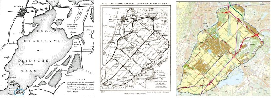
**Water** The Haarlemmermeer municipality used to be a large lake, until around 1850 the land was claimed by pumping out the water. The stock of water was highly reduced by flows that moved the water into surrounding canals (and eventually into the sea). The picture below shows one of the steam engines that pumped the water out. Nowadays pumping and water management facilities are modernized and aim to control the water levels (stock) by means of controlled flows of water. The main inflows are rainfall (conducted by drainage piping systems into local canals) and emerging ground water. Besides, there are flows of water for human consumption and of waste water, which have a stock at the regional water treatment facility. An important part of necessary drinking water comes from outside the area. Some future challenges: ) how to deal with higher peak loads of heavy rain; 2) how to keep the (salt) ground water from rising up to farmlands. Not only flows are important here, but also the creation of extra buffer (stocks) of water. ![enter image description here][1] **Land** The growing villages in the municipality require an amount of sand to be built on. Part of the land (sand) needed is dug out nearby and transported (flow) to the housing area to be built. The photo below shows a new lake where the sand was taken, and the new neighborhood where it was used. There are various locations like this. The new lake is used for recreation purposes. In the future this process will continue for some time, one major project is planned already. For the newly dug lakes will have an impact on the water system, the plans (and resulting stocks and flows) need to be developed with caution. ![enter image description here][2] [picture NOT taken by me] **Density** The third stock is density. There are a few aspects to mention. First, there are 26 villages, many small ones and a few larger ones. Each village has a higher density than its surrounding (farm)land and can be regarded as a node. The second aspect is that from these nodes the density has (mainly) increased and spread over time (except of a village that has been demolished in favor of the airport). This is because of immigration towards the city, and more births than deaths. The three small maps show the difference in density over time (before 1850, around 1855, 2015). The last aspect (that can't be seen on the image) is that as the city gets 'mature', the center of it gets re-developed with higher densities than before. In the future I expect that more building projects will be situated within the town borders, mainly to preserve the remaining open space, and also for other reasons, such as public transport effectiveness with higher densities, the desire to live close to the center. ![enter image description here][3] [1]: http://www.regiocanons.nl/beeld/Noord-Holland/Onderwijscanon%20Amstelland%20en%20de%20Meerlanden/meer/_1000/V10G-NL-HlmNHA_CM00656.jpg [2]: http://mw2.google.com/mw-panoramio/photos/medium/8319629.jpg [3]: https://edxuploads.s3.amazonaws.com/14327407896767256.jpg