Exercise 1: Kensington Gardens (Central London)
FC-01x Future Cities (1st Run) - Exercise 1 : "Making the Invisible - Visible"

Uploaded on 2016-05-09 by tkesarovski
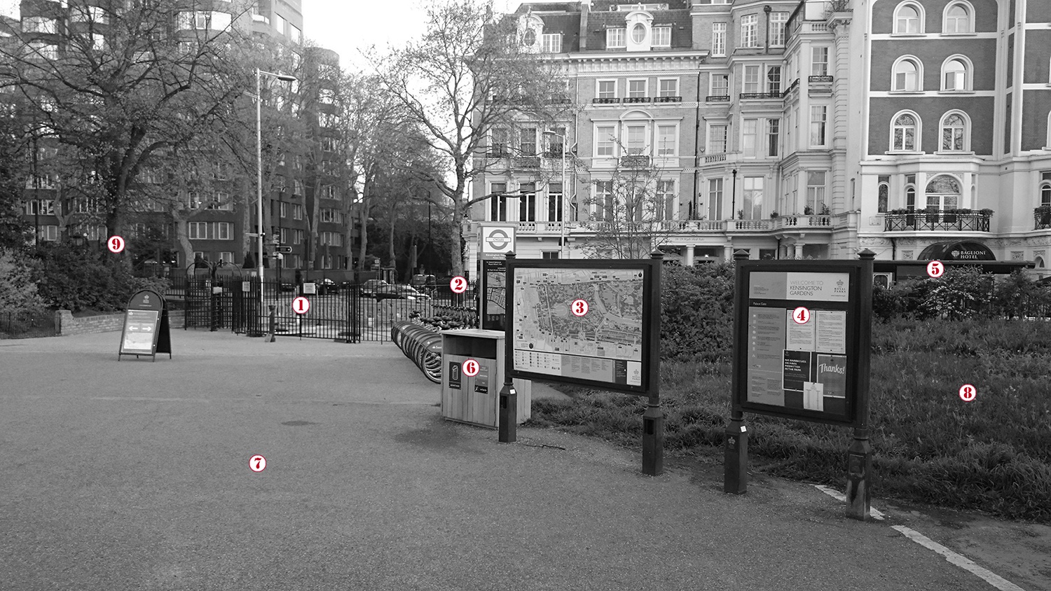
[1]: https://edxuploads.s3.amazonaws.com/14627490671265738.jpg **1_Upload a photo from your area, or the closest urban area, (the photo must be taken by you) and comment all the information that is visible in this photo.** This weekend I was on a visit in London and got some time to delve into its fascinating urban environment, a great place to do my exercise, in fact. The image that I uploaded is from a spot which I found particularly interesting and full of visible and invisible information – at one of the entrance to the Kensington Gardens (Central London) at late afternoon in Monday. First I will present the visible information which is illustrated at the image. [1*] Entrance of the Kensington Gardens which happened to be closed due to maintenance at this moment; [2] A bicycle station, part of the urban bike sharing system in London, apparently full of vehicles at this particular time; [3] Map of the Kensington Gardens illustrating lots of useful navigational information; [4] Public stand for promoting events and initiatives of the local communities taking place in / or around the Kensington Gardens; [5] Bus stop right outside the border of the park; [6] Litter bin having two separate waste collectors: one for general litter and one for recycle waste; [7] Paved alley, part of the whole system which is used for walking and cycling within the Kensington Gardens; [8] A single vegetation area within the Kensington Gardens, part of the whole green structure that shapes the park in what is it; [9] A representation of another essential element of the green infrastructure being vital for the location – a tree. **2_Identify and present two "invisible information" that can be extracted out of the visible information of this photo.** Few examples of “invisible information”, which can be generated, could be identified on the image: [1*] Any entrance of the Kensington Gardens can provide an interesting set of information such as how many people enter and exit the park from that particular spot during the span of a working and weekend day; [2] It is self-evident that the London bike-sharing system, which is digitally monitored, can provide plenty of invisible information, related to how people use this system. For example, how many took a bike from that station how many returned one, from where and to where they travel as well as when they do this; [4] If desired delving into what kind of initiatives or events are organised / promoted within this area can provide a grip on the socio-cultural context of the local neighbourhood and communities; [5] Every bus stop (as a node of the public transport system) can provide practical, mainly quantitative, information in respect to its usage; [7], [8] & [9] Altogether can present an interesting description in respect to the exact characteristics of the park (percentage of vegetation area, paved area or walkways as well as numbers / age of trees in the park). In addition, a closer monitoring of the usage of the pathways within the park can assist us to map the usage intensity of every segment / what kind of user and on which kind of speed. **3_Select one of your choices from the previous question and describe how this invisible information can become knowledge and contribute to the planning of a more liveable urban space.** Based on the notions in respect to the elements which can serve for the collection of “invisible information” most of it can be further elaborated into useful knowledge that can contribute to the enhancement of the urban environment. For the purpose of the assignment, I will focus on the element [1*]: The Kensington Gardens Entrance. As it was mentioned if monitor any park entrance can give us interesting invisible information about how many people enter and exit through it on daily basis. Differentiated, based on different parts of the day and whether it is midweek or weekend can be translated in interesting knowledge about the usage of the park and more specifically, about the quality of a particular entrance. Based on a close monitoring and the collected invisible data we can create simulations about how an entrance of the park should be designed in respect of the internal network of the park but also with the external different modes of mobility networks. The generated knowledge (if found valuable enough) can be translated into design guideline for the London parks or at least integrated as an aspect for simulation of the parks’ usage (at least in the local context).