Madrid and its cameras
FC-01x Future Cities (1st Run) - Exercise 1 : "Making the Invisible - Visible"

Uploaded on 2014-10-12 by quajada
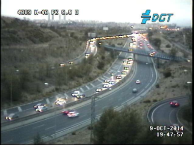
![Speed cameras][1] The visible information is made up of the actual highway, cars, trees, part of the city skyline, etc. as we can see in the picture taken from www.dgt.es : ![DGT traffic camera][2] These photos are taken periodically and provide information on the flow of vehicles at a given time for each highway. The main advantage of having data all day round of all the city’s highways is the possibility to analyse how vehicle-flow patterns evolve across a day, month or even a year. This invisible information can then be used to build new highways sensibly, redirect traffic at given times… minimizing congestion. Another piece of invisible information is seasonal average vehicle speed, which will presumably vary according to climatic conditions. This data can be juxtaposed with number of accidents, illumination, etc. in order to arrive to conclusions that may help with safety, transit times and others. Studies like these may even be able to redefine current parameters like speed limits in future cities. A possible upgrade to these cameras is individual vehicle tracking, where the route of each vehicle is known. This update makes it possible to better understand the city’s inner workings and its people’s spatial distribution with time. Of course, there is a moral aspect to this idea, as some people may feel privacy invasion, but I will not go into this matter. [1]: https://edxuploads.s3.amazonaws.com/14131524786609304.jpg [2]: https://edxuploads.s3.amazonaws.com/1413152447629037.png