Visible & Invisible
FC-01x Future Cities (1st Run) - Exercise 1 : "Making the Invisible - Visible"
Uploaded on 2014-12-09 by AnupamaPodapati
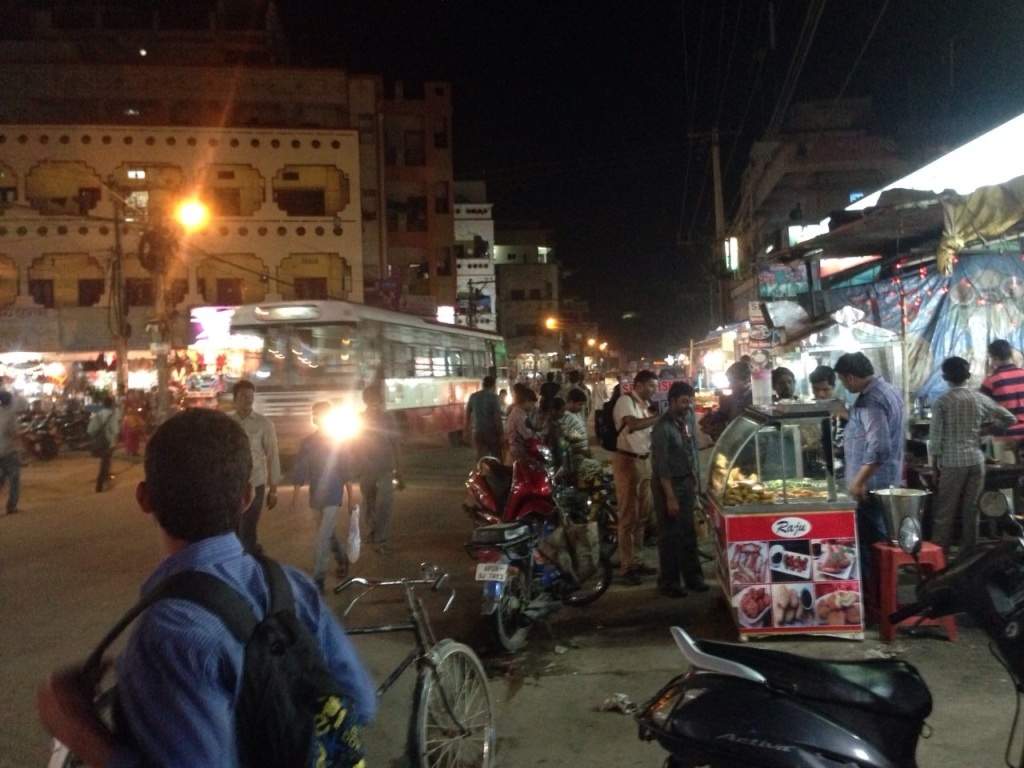
[1]: https://edxuploads.s3.amazonaws.com/1418168199902665.jpg This is an image of a feeder street connecting one of the neighborhood in my area to the major city roads. Though few areas of the city are very well planned, in contrast the city is also filled with areas like this stuck in the randomness of impromptu development. **The visible data from the city** i) Passage of the bus and the guy waiting for it show us that it is a bus route without proper bus bay as a stop ii) The illegal hawking and food stalls leading to haphazard pedestrian movement and also stock of pedestrians blocking the flow of pedestrians iii) Also seen is the lack of proper road infrastructure like footpaths, landscape, safety barriers between traffic and the shop frontage, signages, etc. **The invisible information that can be derived out of it is** i) Traffic constriction all along the street due to spilling of the roadside activities onto the street ii) Increased risk of accidents due to irregular pedestrian movement paths **Measures to be taken with required analysis** i) Pedestrian movement patterns can be mapped and their catchment areas generated thus identifying the major pedestrian routes. Then hierarchy of pedestrian networks can be planned to cater to the need and the demands of future. ii) Separate hawker cum parking zones must be planned at regular locations in the area. This would not only reduce the random on street parking of vehicles and stationary people blocking the way, but planning hawker and food stalls with parking will keep these zones vibrant yet safe as against the risk prone empty parking lots. Thus, a more liveable environment can be generated in such places where impromptu development has reduced efficient planning according to the standards. Leaving such areas to the fate is not a solution.