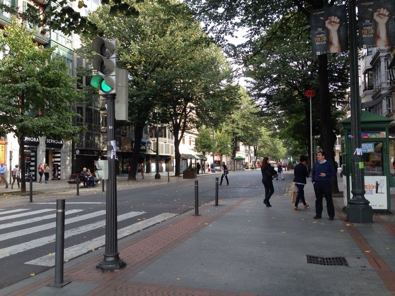
Bilbao – From invisible to visible
FC-01x Future Cities (1st Run) - Exercise 1 : "Making the Invisible - Visible"

Uploaded on 2014-10-14 by ainaraserrano
[1]: https://edxuploads.s3.amazonaws.com/14133133162120392.jpg This is a photograph of the gran via de Bilbao, the projected expansion in 1876 It is the main avenue of the city, and is the commercial and financial center of the capital, home to numerous shops, public institutions and banks. It has a width of 50 meters and a length of 1.5 kilometers. This avenue begins in the Circular Plaza and heads northwest toward the meadows of San Mames. Before the halfway is the elliptical square, from where I have taken the photograph, also called Plaza de Federico Moyúa, which is the nerve center of the widening of Bilbao. 1. WHAT IS VISIBLE? People: We only see about 15 people, which can draw attention to their small number to be a main road to a big city, but this is because the photo was taken at 16.00. Buildings: The street is surrounded by buildings, offices and commercial shops found in its lower part. Transport: In the photo are certain elements of transport such as a bus stop and circulation elements like a traffic light, but we do not see a car. Herbage: we can see a number of trees along the street, which protect pedestrians by providing shade. These were planted during the widening and are lindens, of whose heart-shaped leaves and flowers and relax our nerves of anxious urbanites. Culture: we can see some posters hanging from the lamppost advertising an exhibition. 2. WHAT IS INVISIBLE? Transport: There are many invisible things in transportation for our eyes don´t see. The first thing to do is to highlight the existence of the subway that runs under this street, designed by Sir Norman Foster, and used by residents outside to approach the center. Another factor that we don´t see is that this section of the street was restricted to public transportation, as well as other streets in the city, prompting workers to use public transport, like underground or bus. Knowing this we can conduct studies of the movement of users and their schedules based on the records and make an approach to the reduction of car use in the city center, and the direct relationship of this with a reduction of CO2 in the air. Culture: the posters about exhibitions or museums indicate us that the city cares by culture, and by selling inputs and the location of the various museums and exhibitions in a map can conduct studies of the influx of people, of the relationship the level of studies and economic level of users via surveys, and direct relationship of cultural shows with tourism. 3. FROM INVISIBLE INFORMATION TO KNOWLEDGE The issue of transportation I think is one of the greatest influence in many aspects of the design of future cities, but we will focus on air and energy. The invisible information of the image are noise levels, pollution and energy expenditure that can be quantified. The point is what can we do with this data, the intention is to improve, we can design cities that use less energy or renewable energy. We can also carry out a study of transport and obtain sustainable designs in which users don´t need as far as they need now. All this leads us to future cities with better air quality, lower consumption and an integrated design company.