Exercise 1: Evaluating Street Use in Tokyo
FC-01x Future Cities (1st Run) - Exercise 1 : "Making the Invisible - Visible"
Uploaded on 2014-10-14 by UrbNerd
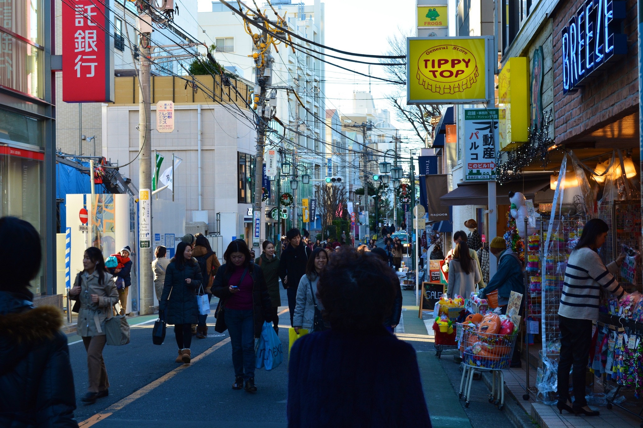
[1]: https://edxuploads.s3.amazonaws.com/14132949901350237.jpg **1)** Above is a typical weekend morning in neighborhood of Jiyugaoka in Tokyo. We see a street lined with a bank, a construction site, a few stores selling knick-knacks, christmas decorations (this picture taken last December) and of course, many shoppers and strollers enjoying themselves. The road beneath them is partitioned into two lanes by a yellow line, and in the distance we can see a traffic light, which is green, and a car or two behind the pedestrian traffic. Despite the fact that the street is crowded with pedestrians, this is perceivably a road also intended for use by cars. However, based on the available visible information, one feels that this street is dominated by pedestrians and that they are the main users, especially given its narrowness and the proximity of stores to the path of movement, with little if any space for parking available. Foot traffic seems to be the order of the day. **2.1)** Returning to the subject of street-use, one piece of invisible information we might glean from this picture is that dominant modes of transportation may differ temporally. Although the markings on the street's pavement give off the impression that it is intended for vehicular use, in the absence of sidewalks pedestrians have moved into the space normally intended for automobiles. On then other hand, while it is a crowded pedestrian street in the picture above, given that it is a weekend this might only be a temporary situation. Further investigation would be necessary to determine normal modes of transportation on this street, and which dominate it at any given time of day or week. **2.2)** To continue on that point, another piece of invisible information we might extract would be a classification of the area's urban function. While one can tell with the naked eye that this is a busy street, understanding which purposes people come for and what activities they engage in here requires further analysis. The human scale of the street not only makes it pedestrian-friendly, but allows easy access to nearby stores and encourages shopping activities. Furthermore, agglomeration of 'general stores' and boutiques selling all manner of home decor, beauty products and more may be found here, and as businesses they must be registered with local authorities. It is therefore possible to understand this area as a shopping district by examining the number of lots which are designated businesses, and furthermore to understand what type of shopping district it is by assessing the precise type of industry they are engaged in. **3)** In regard to the question of street-usage, I would argue that a better understanding of the temporally-dominant modes of transportation in a given urban space have a great impact on its ability to serve its users well in its adopted functions. If decision-makers understand these temporal patterns better, they can make the city more flexible to meet the circumstantial demands placed upon these spaces. In the instance of Jiyugaoka, the invisible information gained from this weekend-scene indicates that the de-facto street use deviates from its supposed use, and might be adjusted on the weekends to divert automobile traffic and improve safety and comfort for pedestrians. Alternatively, it might be decided that sidewalks are necessary, and the road converted to one-lane to accommodate such a change. While further information and projection would be needed before any decision, these are possible courses given the invisible information available.