Uploaded on 2014-11-07 by CarolPeace
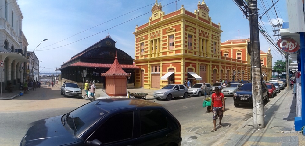
So, to better understand this concept, I’ve chosen the most important stocks and flows that have effect on Manaus (Amazonas, Brazil). First of all, let’s talk about **people – stock and flows** that form the city. According to Brazilian Institute of Geography and Statistics (IBGE), Brazil has a population of 202 768 562 inhabitants (2014). Human occupation is higher on the coastal area hence these were the first areas to be occupied on the beginning of Brazilian colonization; the coastal region is the most developed area in Brazil, that’s why Milton Santos called it *“Região Concentrada”* (Concentrated Region). In this area there is a strong economic presence in the industry , agriculture. In Minas Gerais and São Paulo human occupation followed this pattern, thus caused by the original Portuguese colonization. For Manaus, this is not how the human occupation took place. In the Northern Region, there are still major urban voids as a function of giant internalization and large areas still untouched, as that occupied by the Amazon Rainforest. So, the creation and occupation of the cities was slightly different from the Concentrated Region, therefore, the major urbanism flows only occurred after 1960’s for the reason of the advent of the Free Economic Zone of Manaus. That’s why Manaus only occupies the 21th place of the ranking of the most populous cities in Brazil (158,06 inhabitants/Km²) and Amazonas is the late 26th, with only 2,21 inhabitants/Km², more or less like Australia’s population density. ![Manaus' City Port][1] The Manaus City Port, showing Rio Negro (Negro River) People often arrive to the city by boat, even if after the construction of Eduardo Gomes international airport, the people flows have drastically changed. The major people flows are: - People from other Brazilian states that come to work in the Free Economic Zone of Manaus (inner Brazilian migration – work migration flow); - People that come from the countryside to live on Manaus (inner state migration of people that look for better life conditions – life improvement flow); - Tourists that come to visit the city or that stop here to them go visit the Amazon’s Forest. Manaus is a city that maintains its colonial and its Belle Époque characteristics to enhance the tourism attraction. The picture’s bellow illustrate this preoccupation on maintaining the tourist attractions, since the market is not a trading port nor a popular store anymore; the market has turned into a place that only attends tourists and that not sells the goods (like food) that it used to sell. ![Adolpho Lisboa's Market][2] ![Adolpho Lisboa's Market][3] Adolpho Lisboa’s Market Now, for another important **flow**, that works also as a **stock** within Manaus: **Water**. ![Rio Negro][4] Rio Negro (Negro River), with Rio Negro’s Bridge sight on the background This picture shows two important information at once: **people flow** and **water stock**. Hence Rio Negro’s bridge connects the city of Manaus to the city of Iranduba that used to be a very distant place before its construction. Now, the two cities are connected and the usual people flowing that only used the transportation by boats now occur by land vehicles. The river is a constant people and food flow, since it’s the oldest mean of transportation on the Amazon. The **water** is the most appealing **stock** on modern era. The Amazon Forest was once called the World’s Green Lung, but nowadays we see the forest more like a granary than just a place where you can find big trees and CO2 large stocks. The Amazon forest has the major inland drinkable stock of water in the world, therefore even if the ecosystem drastically changes the river’s volume once or even twice a year, the water it brings from the mountains still makes Rio Negro one of the largest rivers on the world. So, as we understand the Amazon Rainforest as a granary rather than a ‘Green Lung’ we can understand the food flows within Manaus. ![Manaus Moderna][5] The Manaus Moderna City Market The information on the usability of the land and on the best places to settle was the great achievement on Amazon Rainforest’s area. After the Free Economic Zone of Manaus, SUFRAMA (Manaus Free Trade Zone Superintendence) launched a system that gives valuable information to farmers about the best places to settle, grow vegetables and raise cattle that created a great finance flow to the area. Even if about 60% of the food consumed on Manaus comes from other regions (and even other countries), the other 40% is produced on the areas near Manaus, which caused development of certain areas that barely had any chance to integrate the inner Amazon’s market. The percentage of food produced near and within Manaus is growing year by year, making food not only a flow but also a stock within the city. Since Manaus is set really far from the rest of Brazil, it’s important that the city is capable of self sustainability – that’s SUFRAMA’s main focus nowadays. The stocks and flows within Manaus are always changing. As Manaus systematically grows and turns into a bigger city. The water has to be keep as an important stock to the city as well as the preoccupation about the city’s self sustainability. For the future, we always hope that the city will not only grow but will also improve its relation to the forest as well. [1]: https://dl.dropboxusercontent.com/u/54631270/coisas/P1160931.JPG [2]: https://dl.dropboxusercontent.com/u/54631270/coisas/20141102_101350.jpg [3]: https://dl.dropboxusercontent.com/u/54631270/coisas/P1160942.JPG [4]: https://dl.dropboxusercontent.com/u/54631270/coisas/P1160946.JPG [5]: https://dl.dropboxusercontent.com/u/54631270/coisas/P1160938.JPG