Uploaded on 2015-10-19 by Jamesjars
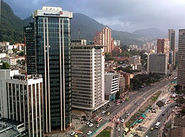
In my city we can get data from the National Forecast System, which in addition to measure temperatures includes as well raining levels. The problem is that this data even though is well acquired; don’t make part of a well-designed system in the whole city that could provide significant data. ![City Cener][1] ![Savannah][2] In these to images we can see downtown Bogotá and the Savannah that surrounds the city. In the city center we can see that most of the buildings are made out of bricks that capture the radiation increasing the average temperature. Most of the surface is constructed with pavement and bricks. In the other picture we can see the Savannah that surrounds the city, the average temperature is higher due to the large amount of vegetation. 3. Which are the measures you would propose? Measures of temeperature in the city light posts for they are in the whole city and can be adjusted to the measure of temperature and humidity Implement green roofs in buildings. Making of more parks in the cities for trees capture radiation for their growth. Encourage the use of bikes for the emission of greenhouse gases affects the temperature of an urban area. 4. Is UHI effect concerning policy making in your area? Unfortunately in my city we don’t have UHI policy for even though we live in the tropic, Bogotá is located over 2600 meters over sea level and the average temperature is cooler than the rest of the city (12-16 °C) [1]: https://edxuploads.s3.amazonaws.com/14452156632820718.jpg [2]: https://edxuploads.s3.amazonaws.com/1445215679713072.jpg